MOUNT YAMNUSKA TRAIL HAS RE-OPENED AS OF NOVEMBER 2021, BUT DUE TO THE REBUILD, THESE DIRECTIONS MAY NO LONGER BE CORRECT.
Mount Yamnuska is an awesome hiking destination with several scenic trails to choose from. Depending on how much excitement you want in one day, you can hike to Raven’s End, the Upper Viewpoint, or the summit. Raven’s End is a popular year-round objective, while the Upper Viewpoint and summit are best done when the trail is dry.
 |
| Mount Yamnuska Upper Viewpoint |
Table of Contents
Mount Yamnuska Hiking / Scrambling Trails at a Glance
- Raven’s End is a family-friendly hike that takes you to the cliff base on the east edge of Yamnuska. 7 km round trip, 460 metres elevation gain.
- Upper Viewpoint offers amazing views of the cliff face, prairies, and Bow Valley for not too much effort. A bit of hands-on scrambling and downclimbing on the return are required. 8 km round trip, 650 metres elevation gain.
- Yamnuska Summit (2,240 metres) is a fun, intermediate-level scramble that should only be attempted in the counterclockwise direction in dry conditions (it’s possible to ascend from the west and avoid the chains and more difficult sections, but it’s a scree bash). The trail has hands-on scrambling, scree, and sections with considerable exposure (major drop offs) including a 30-metre narrow ledge. With its short approach, it’s possible for fit, experienced scramblers to head to the mountain after work and summit before sunset during the summer months. For safety, however, especially if it’s your first time hiking “Yam,” get an early start so you aren’t caught out after dark. Many a hiker has been rescued from this mountain; don’t underestimate it! 11 km round trip, 900 metres elevation gain.
Mount Yamnuska Trail Descriptions
 |
| The beginning is deceptively easy. |
 |
| First junction – turn right |
 |
| Second junction – turn right (follow the arrow) |
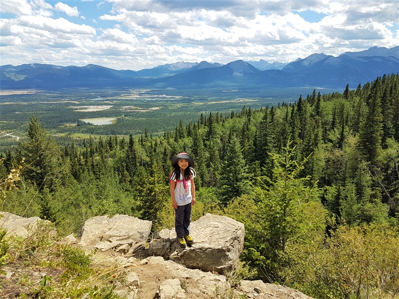 |
| There are great views on the way to Raven’s End! Go as far as you like! |
 |
| Approaching the cliff base of Yamnuska |
Going about 600 metres further, you will come to a crack in the wall blocked by boulders. This would be a good place to put on your rock helmet. Climb over the boulders, continue up the narrow gully, and make your way west to the panoramic Upper Viewpoint. Return the way you came unless you are going for the summit.

 |
| Start of the scramble |
 |
| Follow the blue trail markers to the summit |
 |
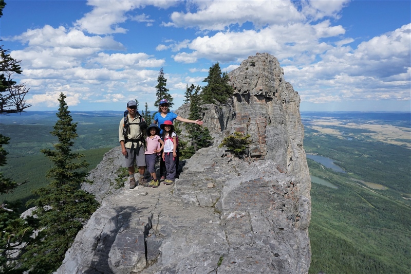
| Mount Yamnuska Upper Viewpoint Stay back from the edge – it’s about a 150 metre drop! |
 |
| Mount Yamnuska Crux: a narrow, 30 metre long narrow ledge. |
 |
| Chain assisted downclimb on Mount Yamnuska (immediately after the ledge) |
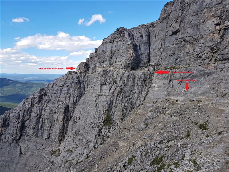 |
| This shot indicates where the chains start (left), where the vertical section is, and where the trail resumes (next blue marker). |
The final push to the summit (300 metres) is steep and loose, but presently you are rewarded with panoramic views of Kananaskis. Once you’ve caught your breath, pop your helmet back on (to protect against rock fall), and descend the west side of Yamnuska. Listening carefully for shouts of “Rock!” from climbers above you, follow the trail to the left, around the front side of the mountain, and traverse to approximately the middle of the rock face . Once you’ve found the longest scree run, “ski” it to the bottom where it connects to a forested trail. Go left (east) until you reach the signed junction, then continue straight to the parking lot.
 |
| Approaching the summit of Mount Yamnuska |
 |
| Looking back into the valley north of Yamnuska |
 |
| Mount Yamnuska Panoramic Summit Shot |
 |
| The descent route |
 |
| Traversing the south face of Yamnuska |
Mount Yamnuska is an exciting scramble that is worth training for! It is typically snow-free from June until November.
Winter Ascent Route of Yamnuska
Know Before You Go
Hiking boots and rock helmet recommended for the Upper Viewpoint and summit. Trekking poles are nice to have for the descent too.
Get an early start or go midweek to avoid the traffic jam at the chains.
You can prepare for Mount Yamnuska by doing steep hikes like Prairie Mountain, and easy scrambles such as Ha Ling Peak, Miner’s Peak, Midnight Peak, East End of Rundle, and Mount St. Piran.
While we took our children to the summit in 2017, please note that we do NOT recommend this hike with children. It was our third attempt and we did a lot of preparation. In addition to taking the girls on several easy scrambles in the years leading up to this hike, we used climbing harnesses and leashes with locking carabiners for the chains section, started early, and went in dry conditions.
 |
| A notch in the rock face, Mount Yamnuska |
Fun Fact: The Mountain with Many Names
 |
| Pin me! |

2 comments
This is a super accessible hike and a great way to get to the alpine. It's awesome to see your kids under safe and experienced parents meet the challenge of the route. Well done !
Thanks Chris! I'm so proud of my girls!! It took us 3 attempts, but there was no way we were going when we were running out of daylight (1st attempt) or hiking in heavy snowfall (2nd attempt – there was no snow in the forecast but you know the Rockies). Glad it was a success and the kids enjoyed it! Now they're asking when they can go on a via ferrata!!
Comments are closed.